 OSU Pytheas - Data Catalog
fichiers NetCDF
Type of resources
Available actions
Topics
INSPIRE themes
Keywords
Contact for the resource
Provided by
Formats
Representation types
Update frequencies
status
Scale
-

In the framework of the SNO/SOERE MOOSE (Mediterranean Ocean Observing System on Environment https://www.ir-ilico.fr/Les-reseaux-elementaires/Fiches-d-identite-des-reseaux-elementaires/MOOSE ) program, the Mediterranean Institute of Oceanography is operating coastal High Frequency Surface Wave Radars (HF radar) on the North Western Mediterranean coast. This activity is also supported by the following European Research Infrastructure Jerico-Next (https://www.jerico-ri.eu), and Intereg MED programs as Impact and Sicomar +. HF radar provide high resolution (3-5 km), synoptic view of surface currents from the shore up to 80 km off shore at hourly time scales. The measurement principle is based on the Doppler effect created by an additional current on the intrinsic speed of the waves selected by radar-sea interactions, called Bragg waves, having a wavelength of half that of the radar e.m. waves and propagating in the axis of observation (radial currents). A single radar scans the sea in azimuth and determines the radial components of the current at each adjacent cell along each azimuth. Two separate radars for the same area from different angles then collect the information necessary for mapping vector current from the combination of the two sets of radial components. The HF radar data set is made of monthly averaged surface currents, geo-referenced on cartesian lon/lat coordinates. The radial velocities maps are provided applying a Direction Finding technique (instead of traditional Beam Forming) not only to the full array of antenna but also to subarrays made of a smaller number of sequential antennas, a method which we refer to as "antenna grouping". Radials from Peyras-Peyras and Porquerolles-Benat are computed to reconstruct the vector field.
-
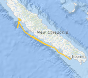
Le projet interdisciplinaire UECOCOT vise à développer des outils d'aide à la gestion durable des activités minières afin de permettre la meilleure cohabitation possible entre dynamique naturelle des environnements (et leur capacité de résistance aux dommages et de résilience) et les activités humaines (industrielles ou non). L'objectif global du projet est de répondre à la question " comment adapter , à un coût socio-économique acceptable, les activités minières pour que leur impact reste compatible avec la durabilité des écosystèmes côtiers et littoraux". Pour atteindre un tel objectif, le projet UECOCOT repose sur une approche multi-sites ayant des impacts miniers différents. Dans le Pacifique sud, le site choisi est le lagon de Koné (Nouvelle-Calédonie) à proximité duquel s'est implanté une mine de nickel et touché par des apports de particules riches en éléments métalliques (Ni, Cr, Co, Mn) issues de l'altération des massifs miniers latéritiques développés sur des péridotites. C'est dans ce cadre qu'a eu lieu en février 2018 une campagnes océanographique multidisciplinaire dans le lagon de Koné dont l'objectif était d'acquérir des informations sur : i) les flux hydrodynamiques et biogéochimiques entre la côte, le lagon et l'océan et les connectivités au sein même du lagon, ii) l'état écologique du lagon et son fonctionnement End to End (hydro-bio-géochimique) , iii) les apports miniers directs ou indirects (avec un focus sur les métaux) et leur impact sur le fonctionnement biogéochimique. L'ensemble des résultats acquis doit permettre de valider un modèle numérique de biologie intégrant les aspects physiologiques et comportementaux des organismes (plancton et benthos) liés à la contamination du milieu et à la circulation hydrodynamique au sein du lagon. Il doit en particulier aboutir à une meilleure compréhension du rôle de la barrière récifale sur la régulation hydrodynamique et ainsi permettre d'affiner les prévisions en terme de contamination du lagon suite à une modification de la structure récifale sous l'effet conjugué de contraintes anthropiques et climatiques. Ce projet s'inscrit dans le réseau international AMEDEE (Activité Minière, Environnement, Développement Economique, Ethiques) qui regroupe les programmes de R&D de 40 institutions scientifiques (Colin, 2016)
-
JULIO (Judicious Location for Intrusions Observations) mooring is located close to the 100 m-deep isobath (around 5.25°E and 43.13°N), offshore Marseille. With its bottom-moored (300kHz) ADCP, it enables measuring horizontal currents (every 4 m and every ½ h) through the water column, and among others, identifying periods of exchange between the Northern Current and the continental shelf. It is one crucial component in the study of the coastal-offshore gradient from Marseille to the MOOSE 42°N5°E station, and potential covariances with the MIO radar and other MIO or international observing systems, as well as with the SOMLIT site (including also an ADCP) in the bay of Marseille. Moreover, with a bottom CTD, it can detect environmental anomalies in classical hydrographic data, useful for oceanographers. As one of the rare station at the interface between the continental shelf and offshore, it will allow to observe the long-term evolution of the Northern Current in the context of climate change and anthropogenic pressure, and its potential varying impact on the Gulf of Lion. The data are of course also crucial for modellers. Moreover they show a great potential when supplementing other MOOSE data (glider and radar). Timeserie #4 : - JULIO 4 - 07/12/2020 to 31/08/2021; JULIO (Judicious Location for Intrusions Observations) est situé à proximité de l'isobathe de 100 m de profondeur (environ 5,25°E et 43,13°N), au large de Marseille. Grâce à son ADCP (300 kHz), il permet de mesurer les courants horizontaux (tous les 4 m et toutes les ½ h) à travers la colonne d'eau et, entre autres, d'identifier les périodes d'échange entre le courant du Nord et le plateau continental. Il s'agit d'un élément crucial dans l'étude du gradient littoral-offshore de Marseille à la station MOOSE 42°N5°E, et des covariances potentielles avec le radar MIO et autres systèmes d'observation MIO ou internationaux, ainsi qu'avec le site SOMLIT (incluant également un ADCP) dans la baie de Marseille. De plus, avec un CTD de fond, il peut détecter les anomalies environnementales dans les données hydrographiques classiques, utiles aux océanographes. En tant qu'une des rares stations à l'interface entre le plateau continental et le large, elle permettra d'observer l'évolution à long terme du courant du Nord dans le contexte du changement climatique et de la pression anthropique, et son impact potentiel variable sur le Golfe du Lion. Les données sont bien sûr également cruciales pour les modélisateurs. De plus, ils présentent un grand potentiel en complément d'autres données MOOSE (planeur et radar). Série temporelle #4 : - JULIO 4 - 07/12/2020 to 31/08/2021;
-
JULIO (Judicious Location for Intrusions Observations) mooring is located close to the 100 m-deep isobath (around 5.25°E and 43.13°N), offshore Marseille. With its bottom-moored (300kHz) ADCP, it enables measuring horizontal currents (every 4 m and every ½ h) through the water column, and among others, identifying periods of exchange between the Northern Current and the continental shelf. It is one crucial component in the study of the coastal-offshore gradient from Marseille to the MOOSE 42°N5°E station, and potential covariances with the MIO radar and other MIO or international observing systems, as well as with the SOMLIT site (including also an ADCP) in the bay of Marseille. Moreover, with a bottom CTD, it can detect environmental anomalies in classical hydrographic data, useful for oceanographers. As one of the rare station at the interface between the continental shelf and offshore, it will allow to observe the long-term evolution of the Northern Current in the context of climate change and anthropogenic pressure, and its potential varying impact on the Gulf of Lion. The data are of course also crucial for modellers. Moreover they show a great potential when supplementing other MOOSE data (glider and radar). Timeserie #5 : - JULIO 5 - 01/09/2021 to 23/06/2022; JULIO (Judicious Location for Intrusions Observations) est situé à proximité de l'isobathe de 100 m de profondeur (environ 5,25°E et 43,13°N), au large de Marseille. Grâce à son ADCP (300 kHz), il permet de mesurer les courants horizontaux (tous les 4 m et toutes les ½ h) à travers la colonne d'eau et, entre autres, d'identifier les périodes d'échange entre le courant du Nord et le plateau continental. Il s'agit d'un élément crucial dans l'étude du gradient littoral-offshore de Marseille à la station MOOSE 42°N5°E, et des covariances potentielles avec le radar MIO et autres systèmes d'observation MIO ou internationaux, ainsi qu'avec le site SOMLIT (incluant également un ADCP) dans la baie de Marseille. De plus, avec un CTD de fond, il peut détecter les anomalies environnementales dans les données hydrographiques classiques, utiles aux océanographes. En tant qu'une des rares stations à l'interface entre le plateau continental et le large, elle permettra d'observer l'évolution à long terme du courant du Nord dans le contexte du changement climatique et de la pression anthropique, et son impact potentiel variable sur le Golfe du Lion. Les données sont bien sûr également cruciales pour les modélisateurs. De plus, ils présentent un grand potentiel en complément d'autres données MOOSE (planeur et radar). Série temporelle #5 : - JULIO 5 - 01/09/2021 to 23/06/2022;
-
JULIO (Judicious Location for Intrusions Observations) mooring is located close to the 100 m-deep isobath (around 5.25°E and 43.13°N), offshore Marseille. With its bottom-moored (300kHz) ADCP, it enables measuring horizontal currents (every 4 m and every ½ h) through the water column, and among others, identifying periods of exchange between the Northern Current and the continental shelf. It is one crucial component in the study of the coastal-offshore gradient from Marseille to the MOOSE 42°N5°E station, and potential covariances with the MIO radar and other MIO or international observing systems, as well as with the SOMLIT site (including also an ADCP) in the bay of Marseille. Moreover, with a bottom CTD, it can detect environmental anomalies in classical hydrographic data, useful for oceanographers. As one of the rare station at the interface between the continental shelf and offshore, it will allow to observe the long-term evolution of the Northern Current in the context of climate change and anthropogenic pressure, and its potential varying impact on the Gulf of Lion. The data are of course also crucial for modellers. Moreover they show a great potential when supplementing other MOOSE data (glider and radar). Timeseries : - JULIO 1 - 12/02/2012 -> 23/10/2012, every 4 minutes ; - JULIO 2 - 26/09/2013 -> 28/03/2014, every 4 minutes ; - JULIO 3 - 17/07/2014 -> 10/04/2015, every 4 minutes ; - JULIO 4 - 07/12/2020 -> 21/08/2021, every 5 minutes ; - JULIO 5 - 01/09/2021 -> 23/06/2022, every 4 minutes ; JULIO (Judicious Location for Intrusions Observations) est situé à proximité de l'isobathe de 100 m de profondeur (environ 5,25°E et 43,13°N), au large de Marseille. Grâce à son ADCP (300 kHz), il permet de mesurer les courants horizontaux (tous les 4 m et toutes les ½ h) à travers la colonne d'eau et, entre autres, d'identifier les périodes d'échange entre le courant du Nord et le plateau continental. Il s'agit d'un élément crucial dans l'étude du gradient littoral-offshore de Marseille à la station MOOSE 42°N5°E, et des covariances potentielles avec le radar MIO et autres systèmes d'observation MIO ou internationaux, ainsi qu'avec le site SOMLIT (incluant également un ADCP) dans la baie de Marseille. De plus, avec un CTD de fond, il peut détecter les anomalies environnementales dans les données hydrographiques classiques, utiles aux océanographes. En tant qu'une des rares stations à l'interface entre le plateau continental et le large, elle permettra d'observer l'évolution à long terme du courant du Nord dans le contexte du changement climatique et de la pression anthropique, et son impact potentiel variable sur le Golfe du Lion. Les données sont bien sûr également cruciales pour les modélisateurs. De plus, ils présentent un grand potentiel en complément d'autres données MOOSE (planeur et radar). Série temporelle #1: - JULIO 1 - 12/02/2012 -> 23/10/2012, toutes les 4 minutes ; - JULIO 2 - 26/09/2013 -> 28/03/2014, toutes les 4 minutes ; - JULIO 3 - 17/07/2014 -> 10/04/2015, toutes les 4 minutes ; - JULIO 4 - 07/12/2020 -> 21/08/2021, toutes les 5 minutes ; - JULIO 5 - 01/09/2021 -> 23/06/2022, toutes les 4 minutes ;
-
JULIO (Judicious Location for Intrusions Observations) mooring is located close to the 100 m-deep isobath (around 5.25°E and 43.13°N), offshore Marseille. With its bottom-moored (300kHz) ADCP, it enables measuring horizontal currents (every 4 m and every ½ h) through the water column, and among others, identifying periods of exchange between the Northern Current and the continental shelf. It is one crucial component in the study of the coastal-offshore gradient from Marseille to the MOOSE 42°N5°E station, and potential covariances with the MIO radar and other MIO or international observing systems, as well as with the SOMLIT site (including also an ADCP) in the bay of Marseille. Moreover, with a bottom CTD, it can detect environmental anomalies in classical hydrographic data, useful for oceanographers. As one of the rare station at the interface between the continental shelf and offshore, it will allow to observe the long-term evolution of the Northern Current in the context of climate change and anthropogenic pressure, and its potential varying impact on the Gulf of Lion. The data are of course also crucial for modellers. Moreover they show a great potential when supplementing other MOOSE data (glider and radar). Timeserie #3 : - JULIO 3 - 17/07/2014 to 10/04/2015; JULIO (Judicious Location for Intrusions Observations) est situé à proximité de l'isobathe de 100 m de profondeur (environ 5,25°E et 43,13°N), au large de Marseille. Grâce à son ADCP (300 kHz), il permet de mesurer les courants horizontaux (tous les 4 m et toutes les ½ h) à travers la colonne d'eau et, entre autres, d'identifier les périodes d'échange entre le courant du Nord et le plateau continental. Il s'agit d'un élément crucial dans l'étude du gradient littoral-offshore de Marseille à la station MOOSE 42°N5°E, et des covariances potentielles avec le radar MIO et autres systèmes d'observation MIO ou internationaux, ainsi qu'avec le site SOMLIT (incluant également un ADCP) dans la baie de Marseille. De plus, avec un CTD de fond, il peut détecter les anomalies environnementales dans les données hydrographiques classiques, utiles aux océanographes. En tant qu'une des rares stations à l'interface entre le plateau continental et le large, elle permettra d'observer l'évolution à long terme du courant du Nord dans le contexte du changement climatique et de la pression anthropique, et son impact potentiel variable sur le Golfe du Lion. Les données sont bien sûr également cruciales pour les modélisateurs. De plus, ils présentent un grand potentiel en complément d'autres données MOOSE (planeur et radar). Série temporelle #3 : - JULIO 3 - 17/07/2014 to 10/04/2015;
-
JULIO (Judicious Location for Intrusions Observations) mooring is located close to the 100 m-deep isobath (around 5.25°E and 43.13°N), offshore Marseille. With its bottom-moored (300kHz) ADCP, it enables measuring horizontal currents (every 4 m and every ½ h) through the water column, and among others, identifying periods of exchange between the Northern Current and the continental shelf. It is one crucial component in the study of the coastal-offshore gradient from Marseille to the MOOSE 42°N5°E station, and potential covariances with the MIO radar and other MIO or international observing systems, as well as with the SOMLIT site (including also an ADCP) in the bay of Marseille. Moreover, with a bottom CTD, it can detect environmental anomalies in classical hydrographic data, useful for oceanographers. As one of the rare station at the interface between the continental shelf and offshore, it will allow to observe the long-term evolution of the Northern Current in the context of climate change and anthropogenic pressure, and its potential varying impact on the Gulf of Lion. The data are of course also crucial for modellers. Moreover they show a great potential when supplementing other MOOSE data (glider and radar). Timeserie #6 : - JULIO 6 - 24/06/2022 to 22/06/2023; JULIO (Judicious Location for Intrusions Observations) est situé à proximité de l'isobathe de 100 m de profondeur (environ 5,25°E et 43,13°N), au large de Marseille. Grâce à son ADCP (300 kHz), il permet de mesurer les courants horizontaux (tous les 4 m et toutes les ½ h) à travers la colonne d'eau et, entre autres, d'identifier les périodes d'échange entre le courant du Nord et le plateau continental. Il s'agit d'un élément crucial dans l'étude du gradient littoral-offshore de Marseille à la station MOOSE 42°N5°E, et des covariances potentielles avec le radar MIO et autres systèmes d'observation MIO ou internationaux, ainsi qu'avec le site SOMLIT (incluant également un ADCP) dans la baie de Marseille. De plus, avec un CTD de fond, il peut détecter les anomalies environnementales dans les données hydrographiques classiques, utiles aux océanographes. En tant qu'une des rares stations à l'interface entre le plateau continental et le large, elle permettra d'observer l'évolution à long terme du courant du Nord dans le contexte du changement climatique et de la pression anthropique, et son impact potentiel variable sur le Golfe du Lion. Les données sont bien sûr également cruciales pour les modélisateurs. De plus, ils présentent un grand potentiel en complément d'autres données MOOSE (planeur et radar). Série temporelle #6 : - JULIO 6 - 24/06/2022 to 22/06/2023;
-
JULIO (Judicious Location for Intrusions Observations) mooring is located close to the 100 m-deep isobath (around 5.25°E and 43.13°N), offshore Marseille. With its bottom-moored (300kHz) ADCP, it enables measuring horizontal currents (every 4 m and every ½ h) through the water column, and among others, identifying periods of exchange between the Northern Current and the continental shelf. It is one crucial component in the study of the coastal-offshore gradient from Marseille to the MOOSE 42°N5°E station, and potential covariances with the MIO radar and other MIO or international observing systems, as well as with the SOMLIT site (including also an ADCP) in the bay of Marseille. Moreover, with a bottom CTD, it can detect environmental anomalies in classical hydrographic data, useful for oceanographers. As one of the rare station at the interface between the continental shelf and offshore, it will allow to observe the long-term evolution of the Northern Current in the context of climate change and anthropogenic pressure, and its potential varying impact on the Gulf of Lion. The data are of course also crucial for modellers. Moreover they show a great potential when supplementing other MOOSE data (glider and radar). Timeserie #2: - JULIO 2 - 17/09/2013 to 28/03/2014; JULIO (Judicious Location for Intrusions Observations) est situé à proximité de l'isobathe de 100 m de profondeur (environ 5,25°E et 43,13°N), au large de Marseille. Grâce à son ADCP (300 kHz), il permet de mesurer les courants horizontaux (tous les 4 m et toutes les ½ h) à travers la colonne d'eau et, entre autres, d'identifier les périodes d'échange entre le courant du Nord et le plateau continental. Il s'agit d'un élément crucial dans l'étude du gradient littoral-offshore de Marseille à la station MOOSE 42°N5°E, et des covariances potentielles avec le radar MIO et autres systèmes d'observation MIO ou internationaux, ainsi qu'avec le site SOMLIT (incluant également un ADCP) dans la baie de Marseille. De plus, avec un CTD de fond, il peut détecter les anomalies environnementales dans les données hydrographiques classiques, utiles aux océanographes. En tant qu'une des rares stations à l'interface entre le plateau continental et le large, elle permettra d'observer l'évolution à long terme du courant du Nord dans le contexte du changement climatique et de la pression anthropique, et son impact potentiel variable sur le Golfe du Lion. Les données sont bien sûr également cruciales pour les modélisateurs. De plus, ils présentent un grand potentiel en complément d'autres données MOOSE (planeur et radar). Série temporelle #2 : - JULIO 2 - 17/09/2013 to 28/03/2014;
-
JULIO (Judicious Location for Intrusions Observations) mooring is located close to the 100 m-deep isobath (around 5.25°E and 43.13°N), offshore Marseille. With its bottom-moored (300kHz) ADCP, it enables measuring horizontal currents (every 4 m and every ½ h) through the water column, and among others, identifying periods of exchange between the Northern Current and the continental shelf. It is one crucial component in the study of the coastal-offshore gradient from Marseille to the MOOSE 42°N5°E station, and potential covariances with the MIO radar and other MIO or international observing systems, as well as with the SOMLIT site (including also an ADCP) in the bay of Marseille. Moreover, with a bottom CTD, it can detect environmental anomalies in classical hydrographic data, useful for oceanographers. As one of the rare station at the interface between the continental shelf and offshore, it will allow to observe the long-term evolution of the Northern Current in the context of climate change and anthropogenic pressure, and its potential varying impact on the Gulf of Lion. The data are of course also crucial for modellers. Moreover they show a great potential when supplementing other MOOSE data (glider and radar). Timeserie #1 - JULIO 1 - 12/02/2012 to 23/10/2012; JULIO (Judicious Location for Intrusions Observations) est situé à proximité de l'isobathe de 100 m de profondeur (environ 5,25°E et 43,13°N), au large de Marseille. Grâce à son ADCP (300 kHz), il permet de mesurer les courants horizontaux (tous les 4 m et toutes les ½ h) à travers la colonne d'eau et, entre autres, d'identifier les périodes d'échange entre le courant du Nord et le plateau continental. Il s'agit d'un élément crucial dans l'étude du gradient littoral-offshore de Marseille à la station MOOSE 42°N5°E, et des covariances potentielles avec le radar MIO et autres systèmes d'observation MIO ou internationaux, ainsi qu'avec le site SOMLIT (incluant également un ADCP) dans la baie de Marseille. De plus, avec un CTD de fond, il peut détecter les anomalies environnementales dans les données hydrographiques classiques, utiles aux océanographes. En tant qu'une des rares stations à l'interface entre le plateau continental et le large, elle permettra d'observer l'évolution à long terme du courant du Nord dans le contexte du changement climatique et de la pression anthropique, et son impact potentiel variable sur le Golfe du Lion. Les données sont bien sûr également cruciales pour les modélisateurs. De plus, ils présentent un grand potentiel en complément d'autres données MOOSE (planeur et radar). Série temporelle #1: - JULIO 1 - 12/02/2012 to 23/10/2012;
-
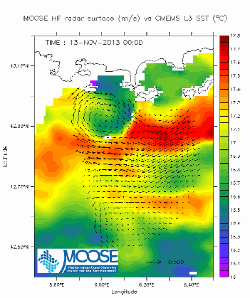
In the framework of the SNO/SOERE MOOSE (Mediterranean Ocean Observing System on Environment) program, the Mediterranean Institute of Oceanography is operating coastal High Frequency Surface Wave Radars (HF radar) on the North Western Mediterranean coast. HF radar provide high resolution (3-5 km), synoptic view of surface currents from the shore up to 80 km off shore at hourly time scales. The measurement principle is based on the Doppler effect created by an additional current on the intrinsic speed of the waves selected by radar-sea interactions, called Bragg waves, having a wavelength of half that of the radar e.m. waves and propagating in the axis of observation (radial currents). A single radar scans the sea in azimuth and determines the radial components of the current at each adjacent cell along each azimuth. Two separate radars for the same area from different angles then collect the information necessary for mapping vector current from the combination of the two sets of radial components. The MOOSE HF radar MEDTLN data set is made of daily averaged surface currents, geo-referenced on Cartesian lon/lat coordinates. Those are computed from hourly total velocity data of level L3B (velocity threshold and GDOP threshold tests passed) for which additional RFI outliers’ eliminations are made using a one inertial period (17h at 43°N) statistical method based on the number of L3B valid data, variance and mean over the 17h period by reference to the long term (full dataset) statistics. The associated quality control (QC) indexes for the hourly data range from 0 (missing or bad values) to 4 (best confidence values). Details of the method available on the MOOSE HFradar website. Velocities, variances and QC values in this file are those averaged on a lunar daily basis (25 hours average) centered at noon of each day. Hourly data for specific studies may be available on equest (see contacts below). DOI : 10.17882/56500 Landing Page = https://doi.org/10.17882/56500